The Long Tarns
With such short winter days it is still dark as we emerge from the cocoon of our sleeping bags and scrabble about for beanie, head torch, down jacket. We have woken from an unwavering 12 hour sleep. The previous day’s walk was not tough but it was 12km, with 600m of elevation gain, some steep pinches towards the end. The scrub was tight in parts and the ground icy. Towards the end of the day I was distracted by a sore back and some vague nausea. Still, the plan this morning is to try for Turrana Bluff. We are camped at Long Tarns on the Great Western Tiers and on the edge of the Walls of Jerusalem National Park. Turrana Bluff is not far away, maybe an hour and half.
In the pre-dawn darkness our torch light picks up tiny, sparkling beads of condensation inside the tent. I unzip the inner door. In the vestibule my leather boots are frozen and stiff. It is 6:30am. Caz throws open the tent fly and instantly the interior condensation freezes. Hard beads of ice form. I run my finger along the tent wall. It feels like reading braille. The morning is clear and still.
Our tent is slippered in amongst a grove of pencil pines. The trees are covered in frost that twinkles and glints. It is easy to see how Northern Hemisphere humans got the idea for decorating Christmas trees with bright baubles. The stars are still clear above. The slither of a crescent moon.
According to local sources (Wilkinson/Nomenclature Board), Turrana Bluff draws its name from the Palawa word for snow and the bluff’s name has been in use since 1947. However, I could find no supporting evidence of Turrana/Snow on the TAC palawa kani website. Palawa kani means ‘Tasmanian Aborigines speak’; it is the only Aboriginal language in Lutruwita (Tasmania) today, and the TAC (Tasmanian Aboriginal Centre) is responsible for the palawa kani Language Program across the state, run since the early 1990s.
Only a handful of places in Lutruwita still bear their original names, although in English spellings which do not convey the original sounds – Triabunna, Ringarooma, Boobyalla are some. What seem like ‘Aboriginal names’ on signs and maps – Yolla, Marrawah, Poatina etc – are all in English spellings too, and were plucked straight from wordlists by various municipal authorities. None of those names are the original names for those places, and are not from the language of that place or area.
So we may or may not be walking to Turrana Bluff. Whatever it’s true name, it is a dramatic, towering wall of a mountain and today it is covered in snow.
Our walk, however, does not get underway until 10:30am. We have been busy enjoying a slow breakfast, warm sunshine, ice photography. In the snow are wallaby and Tasmanian Devil prints. As we round the northern end of Long Tarns, and begin route finding and climbing towards the bluff, there is a good amount of snow and plenty of tricky verglas. My back is fine today but the strange nausea persists and increases with exertion. I stare ahead to the Bluff. It looks a long way away. To our east is a sort of ridge, capped with bulging, rounded dolerite. A high terrace above the lake.
Atop one of the rocks, not too far ahead, is a rare sight. One of Tasmania’s endangered Wedgetail Eagles, perched and silhouetted against the bright sky. We stop. To see this massive bird up here on a winter’s day, surrounded by snow and ice. The Tasmanian Wedge-tailed Eagle is a subspecies (Aquila audax fleayi) of the mainland eagle and it is distinguished by its size (being Australia's largest bird of prey). The total adult population, left in Tasmania, has been estimated at less than 1000 birds.
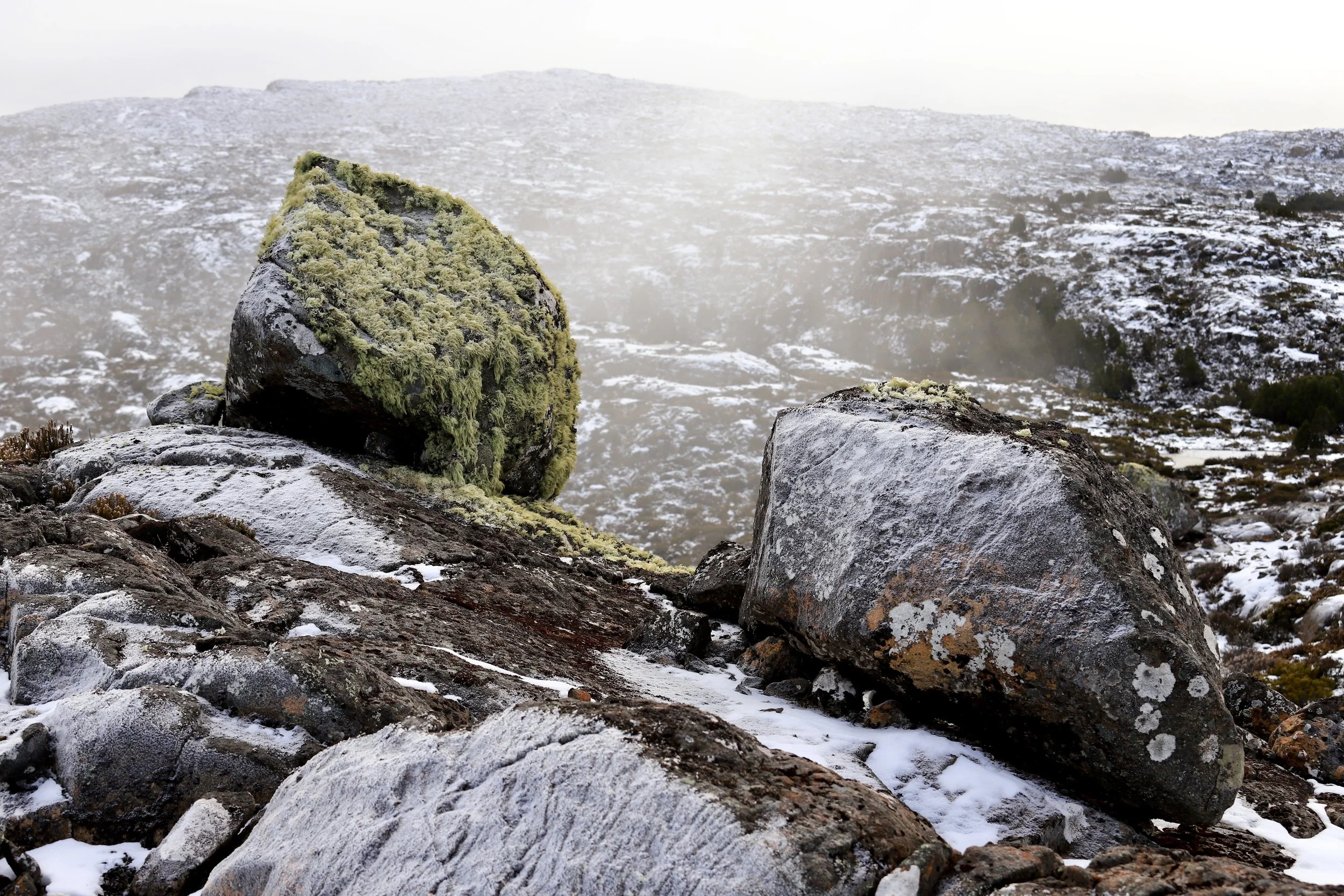
As we continue walking, the eagle launches into the sky and is joined by a second bird that has been resting just out of sight. They drift, playing the wind and disappearing quickly against the mottled background of the hills. The whole performance has felt like a magician’s trick. So, we climb to the eagle’s rock. It is like no other in these mountains. Not the highest, but it is covered in hanging lichen. Draped in the stuff. All the other rocks we see are bare. This one has been decorated profusely, like a shrine. I touch the rock and look down the valley. Behind us, low cloud is forming around the cliffs and drifting across them in thick waves. Turrana Bluff disappears.
When you write about a place being “untouched” or “pristine” or “wilderness” you erase us, our existence, our past and ongoing connection to Country and our essential role as custodians.
With my nausea persisting, and the snow deepening the higher we go, I vote for a more exploratory walk; circling along the high ridge that the eagles took. Heading to the eastern shore of Long Tarn and somehow working our way back to camp. Craig, as always, is happy to be out here, anywhere, and everywhere. He pulls out the map and makes a new plan to track about one kilometre down the tarn where there is a possible, but inconclusive, land bridge to take us back across to the western shore and our camp. Unsure if it will ‘go’. We decide to risk it. The walk is delightful. Every tarn we pass is frozen solid. Several small ones are nestled along the high ridge. The variety of patterns in the ice are sheet music, calligraphy, geometry, cubist art, a circuit board, organic, curvaceous, crystalline. Sometimes all of these in one small frame. As we pass each frozen pond an idea forms. To bring ice skates on winter hikes and start a social media feed called “wild skating”. I can’t ice skate.
We drop into a dense grove of pencil pines and emerge beside the frozen expanse of Long Tarns then begin weaving our way south along it’s eastern shore. The further we get away from Turrana Bluff the better I feel. Nausea dissipates. It could be because the going is easier, the exertion less. But, it makes me think of the Indigenous Ranger we spoke to years ago in Narrabri, NSW, before visiting a remote mountain of unknown sensitivity. We wanted to check it would be okay for us to walk there, that we weren’t breaching any traditional owner’s sensitivities. He didn’t know of any reason we shouldn’t climb the peak but warned us to turn around if we experienced headaches or nausea. I didn’t back then.
Continuing up the edge of Long Tarn, we reach our hopeful land bridge across to the western shore. All the way we have talked about crossing the frozen lake by spreading our bodies out flat and sliding across the ice. But, the land bridge ‘goes’. We step across a few boulders and are done. The walk back to camp is pretty, with long vistas down the lake to the distant, rising, snow-backed heights of the escarpment.
As the day wanes, we disappear into the shelter of our pine grove. Currawongs comes in to roost. The night arrives fast and, just as quickly, disappears again. Another 12 hour sleep. The currawongs call from the top of the pines before heading out to forage for the day. It has been another clear night and the frost is thick. The tarn ice cracks once, like a distant rifle shot.
We take our time on the retreat. The Little Fisher River Track, that is used to access this high country, is beautiful in its own right. Rainforest, moss covered boulders, Rinadena Falls, a high valley of spaghmum moss below the towering walls of Mersey Bluff to the west and Turrana Bluff to the east. There are many threads of thought to follow - back then as I walked and now as I write. Decolonising the landscape and rethinking our definition of wilderness is an important one. And ongoing. Acknowledging the European names we give things is a continuing form of theft. What of the ‘seems like’ Aboriginal names? I started writing this story during this year’s NAIDOC week celebrations. Not with that, necessarily, in mind. This piece was primarily to accompany a new online exhibition of Craig’s photos, themed along our encounters with ice. Many of the pictures were taken at Long Tarns. But then I came across the part in my journal about the nausea, the eagle, the extraordinary rock (pictured). I had forgotten all that. Other facts too. The original trip to Long Tarns was three years ago - during NAIDOC week.
Returning down the Little Fisher River Track. The beauty of the ice covered high places has been bewitching. But, back in the lowlands, the myrtle beech rainforest is like a hug. Thick trunked trees. Patches of hard water fern, set about with moss covered rocks. The ground is a soft sponge of fallen myrtle leaves and humus. The river is small and cascading steeply in parts then settling into a gentle flow. The river rocks are black and slick. There are generous spaces between the trees. We stop another night. Anything to drag out the enchantment. We set up our tent beside this river of constant change. Beneath a tree of unknown antiquity. A robin of uncountable generations flits in, perches on a branch. She is an unremarkable brown colour; a strangely quiet bird. I am alert to her movements. Scanning the forest for her more colourful mate. She does not stay long and is, one minute, gone.
Indigenous poet, Luke Patterson says decolonising the landscape is about the act of disenchanting and re-enchanting*. That is, falling out of love with the colonial myths embedded in my upbringing. Questioning them, and myself. Facing myth’s trickery and absurdity. Cultures are crammed with myths, built on them. Some inspire us in positive ways. Many are exclusive and hide lies. Truer, honest stories, need to be the basis of growth.
* In, The Plant Thieves by Prudence Gibson, NewSouth.